
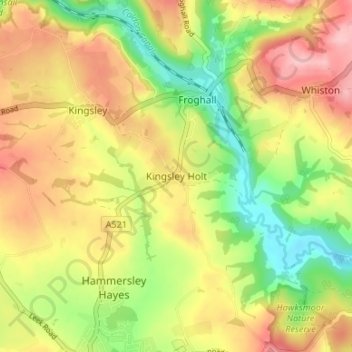
Kingsley Holt topographic map
Interactive map
Click on the map to display elevation.
About this map
Name: Kingsley Holt topographic map, elevation, terrain.
Average elevation: 604 ft
Minimum elevation: 361 ft
Maximum elevation: 837 ft
Other topographic maps
Click on a map to view its topography, its elevation and its terrain.
Alton
United Kingdom > England > Staffordshire > Staffordshire Moorlands
Alton, Staffordshire Moorlands, Staffordshire, England, United Kingdom
Average elevation: 512 ft
Farley
United Kingdom > England > Staffordshire > Staffordshire Moorlands
Farley, Staffordshire Moorlands, Staffordshire, England, United Kingdom
Average elevation: 725 ft
Cheadle
United Kingdom > England > Staffordshire > Staffordshire Moorlands
Cheadle, Staffordshire Moorlands, Staffordshire, England, United Kingdom
Average elevation: 627 ft
Boundary
United Kingdom > England > Staffordshire > Staffordshire Moorlands > Boundary
Boundary, Staffordshire Moorlands, Staffordshire, England, ST10 2NU, United Kingdom
Average elevation: 630 ft
Thorncliffe
United Kingdom > England > Staffordshire > Staffordshire Moorlands > Thorncliffe
Thorncliffe, Staffordshire Moorlands, Staffordshire, West Midlands, England, ST13 7LP, United Kingdom
Average elevation: 1,024 ft
Cheddleton
United Kingdom > England > Staffordshire > Staffordshire Moorlands
Cheddleton, Staffordshire Moorlands, Staffordshire, West Midlands, England, United Kingdom
Average elevation: 669 ft